The Mapped World of the Broken Kaskea Novels (Fantasy)
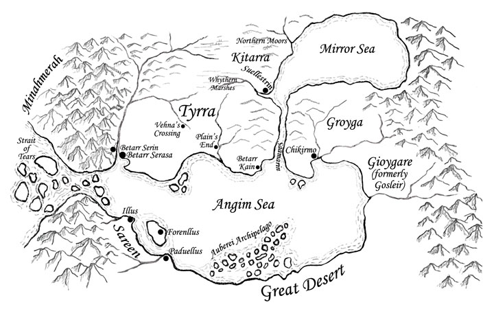
Map, Tyrran Year 1471

Tyrra
The sister cities of Betarr Serin and Betarr Serasa are estimated to be older than 1500 years and are the most populated areas of Tyrra. To the north and east of the sister cities is rich, flat farmland. The forests begin again at the line between Vehna's Crossing and Ruhallen Village (not on map), which sits south of the eastern fork of the Whitewater. The forests continue across northern Tyrra and into the Kainen Peninsula. Plain's End marks exactly what it indicates: the end of flat farmland or pastures. After crossing the river to the east of Plain's End, gently rolling hills begin and seque to rocky hills that climb in elevation. Farms are not found directly east of Plain's end, only a few quarries and lots of scrubby brush. On the eastern side of the peninsula sits the fortress of Betarr Kain, which is younger than the sister cities, but has seen more renovations to its battlements. The strip of forest along the northern border of Tyrra thickens above Betarr Kain and drifts southward. There are no roads, only trails, going through the forests between Betarr Kain in Tyrra and Suellestrin in Kitarra.
|
Population Centers (Old to New)
|
Location
|
|---|---|
| Betarr Serin | Southwest Tyrra, high above the harbor (see map) |
| Betarr Serasa | Southwest Tyrra, next to harbor (see map) |
| Ruhallen Village | Not big enough to be on map. A little north and straight east of Vehna's Crossing, next to the Whitewater. The abandoned hermitage and the Vihrea Hilltops are just south of Ruhallen along the river. |
| Betarr Kain | Southeastern part of Kainen peninsula, south of the Saamarin mouth (see map) |
| Plain's End | South Tyrra, with river access to sea (see map) |
| Vehna's Crossing | Central Tyrra (see map) |
Groyga

Groyga has rich farmland running north-south between Chikirmo and the Mirror Sea. Just like the Tyrran side of the Saamarin, rocky hills rise to cliffs along most of the river. In the southern area about Chikirmo and the Angim, the hills are lower and support vinyards, fruit orchards, and gardens.
Groyga and Tyrra are separated by the river Saamarin, which is named the "river of blood" for good reason. To protect Tyrra and to reduce the bloodshed among humankind, the Phrenii established the lightning wall along the Saamarin, which was non-lethal, but couldn't be crossed. In T.Y. 1293, Groyga started the Fifteen Year War by invading the Kainen peninsula from the south and Tyrra increased the coverage of the lightning wall to Betarr Serin and established Betarr Kain as an outpost. In T.Y. 1456, the lightning wall was dismantled because the Fevers had decimated much of the world, perhaps due to lack of communication. At the beginning of 1471, Tyrra and Groyga are considered to be at peace.
Kitarra
Squeezed between the huge Whythern Marsh to the west, the moors to the north, the Mirror Sea to the east, and the Tyrran border to the south, Kitarra's main city Suellestrin can have harsh weather. Most of the population lives in or near the city.
Kitarra was originally a colony of Tyrra, started by King Voima around T.Y. 850. It had only been intended to be a protective outpost because the nearby marshes and moors limit the amount of land for agriculture or colonization. Over the centuries the original Tyrrans interbred with native marsh people to produce Kitarrans, although well-bred Kitarrans today wouldn't consider they have much in common with the marsh people. In T.Y. 1107, Kitarra gained a peaceful independence from Tyrra. In 1471, the Ungought (pronounced "en-geth") family rules Kitarra. However, it is not a politically benevolent environment: the current King Markus resorted to fratricide to gain control of the crown.
Sareen
Sareen is an alliance of three city-states named Illus, Forenllus, and Paduellus. Each of these massive cities is sited over a aquifer that services many deep wells, so manual irrigation is possible. Illus also has the benefit of water coming off the southern Cen Cerinas mountains, so there are farms, orchards, and pastures between the city and the mountains. Illus provides mountain-grown lumber for the ship-building industry in all the city-states; trade between cities is usually safe and quick through protected waterways. Olive trees and cotton plants provide major export products.
Minahmerah
The Auberei Archipelago

The Auberei Archipelago is a string of islands that juts into the Angim Sea and, unfortunately, provides wonderful havens for pirates. At the beginning of 1471, the most famous pirate that merchants fear is Frisson Rhobar, who used the archipelago as cover for twelve years. Rumors are that Rhobar started out as a respected venture captain (mercenary) and eventurally degraded to piracy after capturing and ransoming a Noble Light of the Church of the Way.
The Strait of Tears

The Strait of Tears is named for both the shapes of the islands, as well as the widows it has made. The Strait is treacherous and the western-most islands have not been mapped entirely, because ships that go too far westward never make it back. However, the day of the galley is past and Sareen is developing a new ship that might be able to handle the heavy storms and strong currents encountered by sailors on the western end of the strait.
